Andrew Garcia
Geospatial Analyst

Andrew Garcia Geospatial AnalystAndrew Garcia Geospatial AnalystAndrew Garcia Geospatial Analyst

Andrew Garcia
Geospatial Analyst

Andrew Garcia Geospatial AnalystAndrew Garcia Geospatial AnalystAndrew Garcia Geospatial Analyst
More

Purpose

Utilize GIS technologies and tools to solve complex system problems. Leverage the full range of GIS capabilities to spatially analyze; quantify, discover patterns, and predict outcomes using a blend of proprietary and open sourced software to assist stakeholders in making comprehensive decisions.

What does that mean?

In short - spatial analysis studies and solves (geo)locations problems using math in maps by blending geography with modern technology to measure, quantify, and understand the world or even a small fragment of the world and its systems.


What can I do for you?


By using GIS (Geographic Information Systems) to spatially analyze, I can quantify, find patterns, and predict outcomes. I then interpret the data to help you make informed decisions in the form of a full comprehensive report. My work consists of a repertoire of cartography created with real world spatial data including some of my favorites such as: 3D spatial renderings, data visualizations, surface prediction, space-time cubes, hexagonal binning, point-density, and various cartograms.


The following contents illustrates my work in GIS both academically nd professional experience. 

Credentials

Experience

Research Analyst | JLL | Feb 2022 to Present| Seattle, WA

  • Deliver interactive mapping solutions via ArcGIS Pro, manage information and insights through Tableau, with a focus on commercial real estate market conditions, trends and forecasts, as well as economic and demographics activity 
  • Subject Matter Expert for industrial brokerage leaders and researchers in PNW region. 
  • Respond to internal stakeholders and external client requests for various data inquiries and information. Manage regional databases and produce statistics reports/articles for national quarterly publication.   

Adjunct Professor - GIS | Seattle University |Winter Qtr |Jan 2022 - Mar 2022|

  • Teach Introduction to Geographic Information Systems as a required cross-listed course for Environmental Sciences and Geography undergraduates. 
  • Introduce students to social and environmental case studies using GIS applications related to urban and environmental planning. 
  • Fundamentals of cartography, spatial data, spatial analytics and methodologies, and data visualizations using ArcGIS Pro (required software). 
  • Basics of ArcGIS Pro Enterprise and geodata management in lab setting.


GIS Analyst | Kaart |Jul 2018 -  Dec 2021| Seattle, WA   

  • Led small consulting team; developed comprehensive business continuity plan for sales strategies and spatial analytic project workflows.
  • Turn by turn navigation (pedestrian & automobile) & street cam ground surveying. Realize geographic model deficiencies in global road network transportation system; drove data quality mapping improvement with less than 2% error
  • Mentoring program developer and leader- Training and development for 30 new employees to energize teams and facilitate greater employee engagement, nurture, and develop skills and talent.
  • Strengthen employee tenure; conducted quarterly open discussion-feedback sessions to better determine employees experience, needs, and potential new implementations


Municipal Solid Waste Consultant| Republic Services |2014 – 2017| Seattle, WA 

  • Set operational sustainability goals for clients such as Amazon & Microsoft to meet and exceed city of Seattle and King county regulations by conducting comprehensive waste assessment evaluations.
  • Spokesperson for Republic Services at sponsorship events; trade shows; Chamber of Commerce; City of Seattle and King County monthly meetings.
  • Exceeded company annual revenue goals by over 150% in 2015 and 2016; Salesforce (CRM) Super User of Western Region
  • Nominated and selected as the highest performer nationwide for landfill byproduct diversion-zero waste initiatives. 


Sustainability Coordinator| PayPal |2010 – 2013| Chandler, AZ 

  • Develop and implement business continuity plans i.e. carbon reduction, energy efficiency, solid waste impact, and cost-benefit analysis
  • Internal and external expert on zero-waste innovative solutions for 1000+ employees and community members.  
  • Developed and managed environmental educational awareness outreach programs and created PayPal/Ebay’s first Green Team in AZ.  
  • Outstanding Achievement Award from both Director and VP of PayPal for developing and leading The Power of Introversion, Creativity, and Education for over 450 employees.  


Sustainability Liaison| State Farm Inc|2008 - 2010| Tempe, AZ

  • Led company-wide process driving environmental stewardship via waste reduction and water conservation while achieving cost benefits.
  • Sustainability and environmental awareness events coordinator for local region call centers (2000+ employees)
  • Author and gatekeeper of sustainability articles, tips, guidelines, and best practices for State Farm Employee Education and Green Space Blog

Education

MS | Geographic Information Systems, Department of Geography

MS | Geographic Information Systems, Department of Geography

MS | Geographic Information Systems, Department of Geography

Geospatial analytics framing a sustainable systems problem; plan and approach geodesign workflow; geodatabase development; complex system interrelationship analysis; and report/propose spatial-temporal systems recommendations.

2017 - 2019 Cohort

BA | Sustainability, Global Institute of Sustainability

MS | Geographic Information Systems, Department of Geography

MS | Geographic Information Systems, Department of Geography

Arizona State University’s School of Sustainability is the first comprehensive degree-granting program of its kind in the United States, with a focus on finding real-world solutions to environmental, economic, and social challenge.  

2014

Foreign Ex. Mandarin Chinese Linguistics

MS | Geographic Information Systems, Department of Geography

Foreign Ex. Mandarin Chinese Linguistics

中文和中国文化学-国际留学生

Chinese language and Chinese Cultural Studies -International exchange student 2013 


Projects

GSI (Green Stormwater Infrastructure) City of Bothell, WA

Priorities for Topo-bathymetric Lidar Data Collection | Alaska

GSI (Green Stormwater Infrastructure) City of Bothell, WA

This study intersects the City of Bothell map of Intact Habitats Cores and highly developed zones with layers of water flow, hazard areas, and other types of land use. It considers complex sustainable system interactions amongst surface water, natural habitats, and flood management issues. 

Viewshed Analysis | City of North Bend

Priorities for Topo-bathymetric Lidar Data Collection | Alaska

GSI (Green Stormwater Infrastructure) City of Bothell, WA

Visibility from selected point locations downtown North Bend, WA to Mt Si

Explore data in 3D - simulate different viewpoints and gain insight to visibility conditions by identifying suitable locations to assess the visual impact of potential new buildings on the wider cityscape; investigate sight lines between buildings from the city to mountain views.  


View presentation here

Priorities for Topo-bathymetric Lidar Data Collection | Alaska

Priorities for Topo-bathymetric Lidar Data Collection | Alaska

Priorities for Topo-bathymetric Lidar Data Collection | Alaska

Determine the top priority areas for topo-bathymetric data collection (hexagonal binning) given the background of scarce modern topo-bathy data and limited funding available for data collection. 

Surface Map Prediction Hanford Nuclear Site

Surface Map Prediction Hanford Nuclear Site

Priorities for Topo-bathymetric Lidar Data Collection | Alaska

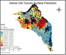
Custom script tool aims to demonstrate impacted study areas from nuclear waste to visualize hazardous waste permeation & provide knowledgeable visual information regarding past, present, and future costs to the environment, economy, and human wellness.  

My Open Street Map Contribution

Surface Map Prediction Hanford Nuclear Site

My Open Street Map Contribution

Dot density (Heat Map)  visualizing my contribution to the Open Street Map community for large scale client satisfaction including turn by turn navigation across the globe. 


Sea level Rise | Everett, WA

Surface Map Prediction Hanford Nuclear Site

My Open Street Map Contribution

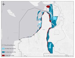
Sea level rise prediction to determine area landcover in Everett, WA that would be impacted by 1 meter (SLR), 5 meter (SLR) & 10 meter storm surge and how that would impact structures, transportation network, and wetlands.   

Skills


Endorsements

Achievement

Downloadable Credentials

  1. Resume
  2. Portfolio (truncated)
  3. Masters of GIS Diploma

GIS_Analyst_Garcia_Andrew (pdf)

Download

Portfolio_GIS_Analyst_2021 (pdf)

Download

Verifiable_MS_GIS_Diploma (pdf)

Download

Resume

Andrew Garcia GIS Analyst

Download PDF

Contact Me

This site is protected by reCAPTCHA and the Google Privacy Policy and Terms of Service apply.

Andrew Garcia

Social

Copyright © 2022 GeoDrew- All Rights Reserved.